A PERMAFROST INVESTIGATION 

A Permafrost Investigation


The history of Fairbanks is replete with a long line of permafrost-related foundation damage and associated building distress.  Many if not most of those situations were completely avoidable and preventable with proper planning, including a permafrost investigation.


The following video PowerPoint presentation illustrates the construction process and its impacts on permafrost and it is described in more detail in the following section.


The author performing a permafrost investigation at a local Fairbanks building site in 1997. Note the whitish material on the auger. This material is massive ground ice. Likely wedge-ice.

Planning for a permafrost investigation begins with a basic understanding of the general area and the expected subsurface conditions.  This understanding is based in part upon past experience in the general area, and in part upon the observable surface features that are present at the specific site of interest. 


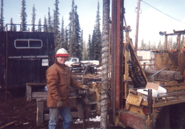
Of the methods locally available to perform a permafrost investigation in Interior Alaska, given the depth that must often be explored for most structures, boreholes advanced using drilling equipment are most practical.  Of the drilling techniques available to drill the holes, boreholes drilled using an auger rig (see image above) are usually preferred.  The total depth, number, and spacing of the boreholes varies with each specific situation.


For a modestly-sized (<2,000 square feet) single-family dwelling located in an area that is generally understood to be permafrost free, which does NOT lie close to an area of known permafrost (e.g., a permafrost boundary), at least two boreholes are good practice to begin to characterize subsurface conditions at the site of interest.  Depending on the conditions encountered and the wishes of the Client, additional borings may be suggested.  For larger structures, naturally, a greater number of boreholes is justified.


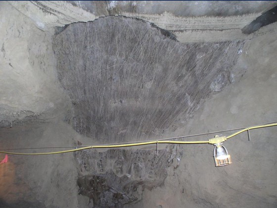
In areas of known permafrost, or in transitional areas (areas separating known permafrost areas from areas that are generally permafrost free), a greater number and tighter spacing between boreholes is always recommended by SYNGEN for any structure, regardless of size.  In such permafrost boundary areas, subsurface conditions can change rapidly and such changes can include unidentified lobes or isolated masses of permafrost that are difficult to detect with too few borings or with many borings that are too widely spaced.  In such locations a greater number and tight spacing of boreholes reduces the risk of unidentified hazards. To further characterize subsurface conditions across a building footprint in high risk areas, subsurface temperatures can be measured (see image below).  Departures (towards freezing) in, say, one borehole from temperatures measured in the four others where temperatures were measured to be unfavorable for large masses of permafrost may indicate an isolated mass of permafrost nearby that borehole and such information could be used to locate additional boreholes in an effort to identify the source of the cooler temperatures.

Subsurface temperatures measured in nine boreholes drilled for a building site located very close to a known permafrost boundary. The ground temperatures are cool (~35F) below about 12 feet, but not frozen (red hatched line shows 32 F isotherm).

While in some areas, no practical number of boreholes can always rule out all risk in every case, a minimum of five boreholes (the four building corners and the building center) are recommended for modestly sized buildings located in or near areas identified as permafrost boundaries.


SYNGEN's methodology used to explore a given site for permafrost conditions generally includes the following:


      • Review of mapped soil and geologic conditions;
      • Review of SYNGEN's own database of subsurface conditions across the Interior from previous explorations over the years;
      • Review of available site aerial imagery;
      • Review of available hydrogeologic information (nearby water well logs);
      • Site walkover by experienced personnel;
      • Drilling and sampling program;
      • Instrumentation program, and;
      • Laboratory analyses as required.


Upon completion of the above work, a geotechnical foundation evaluation report is prepared that presents the findings from the field work, and provides conclusions and recommendations regarding a path forward. 


Recommendations generally include:


      • Suitable foundation type;
      • Geotechnical foundation design information, and;
      • General construction considerations.


Recommendations may also include:


      • Water supply considerations, and;
      • Wastewater disposal considerations.


The process normally takes three to four weeks from the time of drilling to the completion of the final report.  However, verbal results are often available the day that the drilling is completed.  


One of the more infamous results of improper construction on permafrost, along with snapshot of the culprit, is shown below.

THE VICTIM: a homestead cabin built over non thaw stable permafrost.  Note the concrete foundation system which, along with the stiffness provided by the log walls, has permitted the structure to remain mostly intact as thaw related settlement advanced.

THE CULPRIT: MASSIVE GROUND ICE:  Shown is a photo of massive wedge ice buried deep in the ground.  Such deposits are often not visible from the surface and do not show themselves until heat from the building reaches them.  This particular image was taken from a tunnel bored into permafrost in an area near Fox, Alaska.  It is representative of the types of ground ice deposits that can be found in Fairbanks permafrost which upon thaw, can cause catastrophic damage to improperly constructed foundations.